Call For Enquiry
+977-9841390387

The Annapurna Base Camp Trek is a famous trail in the Annapurna region of Nepal that showcases breathtaking views of the Annapurna massif, including Annapurna South, Annapurna I, Hiunchuli, and Machhapuchhre.
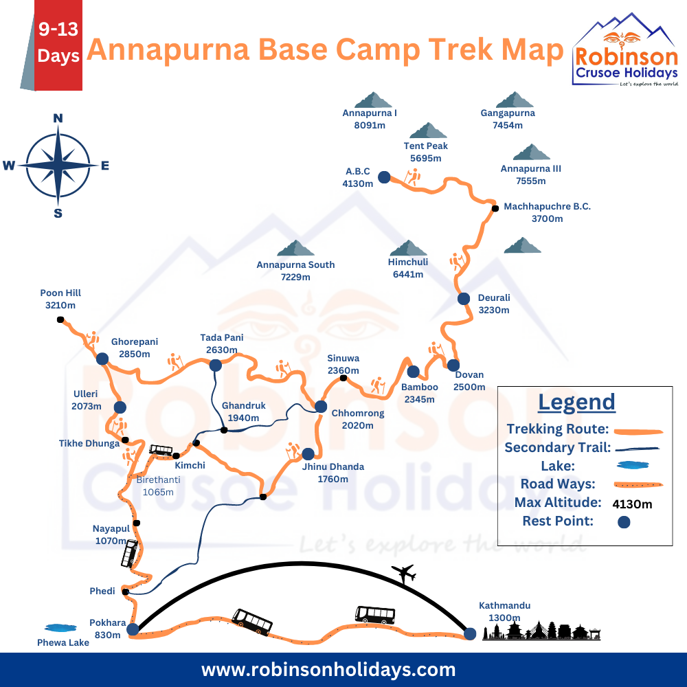
To navigate the trekking route, maps are crucial, particularly the Annapurna Base Camp Trek Map and the Annapurna Circuit Map, which provide details on the route, elevations, landmarks, and other helpful information. The Annapurna Base Camp Trek Map usually contains information such as the trekking route from Nayapul to Annapurna Base Camp, altitude profiles of the trekking route, the location of accommodations such as teahouses and lodges, water sources, rest stops, landmarks, and emergency contact information.
Annapurna Base Camp Trek Map
Moreover, trekkers may use GPS devices or mobile apps to track their location and progress along the route. Nevertheless, while maps and technology are useful, they should not be solely relied upon. Trekkers must bring a paper map as a backup and be ready for any unforeseen changes in weather or trail conditions. It is also recommended to employ a local guide or porter who knows the trekking route and the terrain.
Navigating the Annapurna Base Camp Trek: Your Ultimate Guide with Maps
Introduction: Embarking on the Annapurna Base Camp (ABC) trek is a thrilling adventure, but having the right map and route information is crucial to ensure a successful journey. In this comprehensive guide, we’ll provide you with essential insights and detailed maps to help you navigate the ABC trek and explore the stunning Annapurna region. Let’s dive into the ABC trek map, route details, and everything you need to know for an unforgettable experience.
Annapurna Base Camp Trek Map: Your Path to Adventure
Before setting off on your journey, let’s start by exploring the Annapurna Base Camp trek map. This map outlines the entire route, showing key waypoints, villages, and the mesmerizing landscapes you’ll encounter along the way. Take a closer look at the map below to get a sense of what lies ahead.
Annapurna Base Camp Trek Map:
For a more detailed look at the ABC trek route, refer to the map below. This map includes specific waypoints, elevation information, and distances to help you plan your daily treks and accommodations.
If you need any assistance to explore Annapurna Base Camp with our expert guides then mail us at [email protected] or [email protected]. Or you can directly call us on 977 9841390387. For more details, you can check our website.
Exploring the Annapurna Region
While trekking to Annapurna Base Camp is a remarkable experience, don’t forget to explore other attractions in the Annapurna region. This area boasts diverse flora and fauna, pristine lakes, and unique cultural experiences. The map below highlights some of the region’s must-visit places:
Trip Info
- Trip Days: 12 Days
- Max-Elevation: 4170 m at Annapurna Base Camp
- Best Seasons: Autumn & Spring
Outline Itinerary:
- Drive from Kathmandu to Pokhara (830 m.)
- Drive from Pokhara (830 m.) to Birethanti (1050m.) then trek to Ulleri.
- Trek from Ulleri to Ghorepani (2675 m.)
- Early morning hike up to Poon Hill (3232 m.) and trek to Tadapani.
- Trek from Tadapani to Chhomrong (2,140m)
- Trek from Chhomrong to Dovan (2600m)
- Trek from Dovan to Macchapuchre Base Camp (3700m).
- Trek to Annapurna Base Camp (4170m) from Macchauchre.
- Trek back to Bamboo (2,300m) from Annapurna Base Camp.
- Trek back to Jhinu Danda (1780m.) from Bamboo.
- Trek back to Syauli Bazar (1890m) from Jhinudanda (1750m) and then drive
to Pokhara. - Thus, the Drive from Pokhara to Kathmandu takes about seven hours.
In conclusion
This comprehensive article addressed frequently asked questions about the ABC (Annapurna Base Camp) trek and provided useful information about the route and its surroundings. The breathtaking scenery of the trek adds to its allure, and devotees frequently seek out comprehensive information regarding the ABC trek route, trekking map, and Annapurna trek map.
Understanding the intricate details of the route is crucial for those beginning the ABC trek. The ABC trek route has been extensively covered in this article, providing a comprehensive look at the path that trekkers take to reach Annapurna Base Camp. The Annapurna trek map is included as a visual aid for trekkers to use in navigating the terrain and taking in the unique landscapes.
The ABC trekking map and the Annapurna Base Camp trek map are among the most frequently asked questions in the article. When trekkers plan their trips, their curiosity and need for precise information are reflected in these questions. The inclusion of these details aims to make it easier for trekkers to make educated choices and guarantee a memorable and safe trek.
Significance of Keywords
This article acknowledges the significance of keywords like “ABC trek route,” “ABC trekking map,” “ABC trek map,” “Annapurna trek map,” “Map of Annapurna Base Camp trek,” and “Annapurna Base Camp trek route map” in the context of online searches. The article has made an effort to answer these questions in their entirety because they are important terms for people looking for specific information about the ABC show.
This article aims to be a useful resource for trekkers by incorporating essential keywords and responding to frequently asked questions, giving them the information they need to plan and start a successful Annapurna Base Camp trek. This article aims to be a comprehensive guide for those looking for adventure in the majestic Annapurna region. It will cover everything from comprehending the route to exploring the most frequently asked questions about the trek.