Call For Enquiry
+977-9841390387

The Everest Base Camp Trek Map is a highly sought-after trekking experience in Nepal that attracts many adventure enthusiasts worldwide. The trek leads to the base camp of Mount Everest, the highest peak in the world and a feat of nature that has captivated the human imagination for centuries.
The trekking route winds through the picturesque Khumbu Valley, surrounded by majestic Himalayan mountains such as Mount Everest, Lhotse, Nuptse, and Ama Dablam. This makes the trek an incredibly scenic and awe-inspiring journey, where trekkers can immerse themselves in the beauty of nature and the magnificence of the world’s highest mountains.
To help trekkers navigate and plan their journey, there are several maps available for the Everest Base Camp Trek. These maps provide valuable information on the terrain, the trailheads, the campsites, and the lodges along the way. By using these maps, trekkers can ensure that they are on the right track and can plan their itinerary accordingly.
However, it is important to note that while maps can be helpful, they should not be relied on as the sole means of navigation. The terrain can be challenging and the weather can be unpredictable, so it is highly recommended to also bring a guidebook and hire a local guide who is familiar with the terrain and can provide valuable insights and assistance throughout the trek.
Comprehensive Guide to Everest Base Camp Trek
Embarking on the iconic Everest Base Camp trek is a dream come true for adventurers worldwide. The journey takes you through breathtaking landscapes, and a well-detailed map is your trusted companion. In this article, we’ll explore the essential Everest Base Camp trek maps, including variations like the Three Passes Trek and Gokyo Lake Trek. Get ready to unravel the beauty of the Himalayas through these detailed maps.
Three Passes Trek Map:
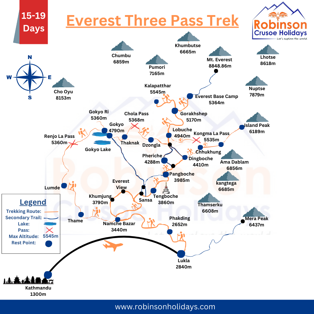
Trip Info:
Trip Days: 12 Days
Max-Elevation: Kalapatthar (5,555m)
Best Seasons: Autumn & Spring
Outline Itinerary
Day 1. Fly from Kathmandu to Lukla (2860m) and trek to Phakding (2,610m)
Day 2. Trek from Phakding to Namche Bazaar (3,440m)
Day 3. Rest day in Namche Bazaar for acclimatization and trek to Hotel Everest View
Day 4. Trek from Namche Bazaar to Tengboche (3,887m)
Day 5. Trek from Tengboche to Dingboche (4,360m)
Day 6. Trek from Dengboche to Chhukung (4,730m)
Day 7. Rest day in Chhukung for acclimatization
Day 8. Trek from Chhukung to Lobuche crossing Kongma La Pass (5,535m)
Day 9. Trek from Lobuche to Everest Base Camp (5,360 m) and stay at Gorakhshep
Day 10. Climb Kalapatthar (5,545m) and trek to Dzong La (4843 m)
Day 11. Trek Dzong La to Gokyo Lake by crossing Cho La Pass (5,380m)
Day 12. Climb to Gokyo Ri (5,420m) and back to Gokyo for acclimatization
Day 13. Trek from Gokyo to Lungden (4380 m) by crossing Renjo La Pass (5,388m)
Day 14. Trek from Lungden to Thame (3,800m)
Day 15. Trek from Thame to Namche Bazaar
Day 16. Trek from Namche Bazaar to Lukla
Day 17. Fly back to Kathmandu from Lukla
In conclusion, Whether you’re setting out on the classic Everest Base Camp trek or opting for the more challenging Three Passes Trek, a reliable map is your best friend. These maps will ensure you stay on course and help you uncover hidden gems along the way. Prepare for an unforgettable journey amidst the grandeur of the Himalayas with these indispensable resources.
Everest Base Camp Trek Map Route (12 days)
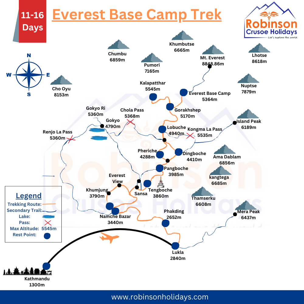
Trip Info:
Trip Days: 12 Days
Max-Elevation: Kalapatthar (5,555m)
Best Seasons: Autumn & Spring
Outline Itinerary
Day 01: Fly from Kathmandu to Lukla (2800 m) and trek to Phakding (2610 m ),
Day 02: Trek from Phakding to Namche Bazaar (3440 m),
Day 03: Acclimatisation day at Namche Bazaar
Day 04: Trek from Namche Bazaar to Tyangboche (3860)
Day 05: Trek from Tyangboche to Dingboche (4360meters)
Day 06: Acclimatization day at Dingboche
Day 07: Trek from Dingboche to Lobuche (4950 m )
Day 08: Trek from Lobuche to Gorakhshep (5160meters) and hike to Everest Base Camp (5400meters)
Day 09: Hike to Kalapatthar (5545meters) then trek to Pangboche (3985)
Day 10: Trek back from Pangboche to Namche Bazaar
Day 11: Trek back from Namche bazaar to Lukla
Day 12: Fly Back to Kathmandu from Lukla
Everest Base Camp Trek with Gokyo Ri Route Map (15 days)

Trip Info:
Trip Days: 15 Days
Max-Elevation: Kalapatthar (5,555m)
Best Seasons: Autumn & Spring
Outline Itinerary
Day 1: Flight from Kathmandu (1,400m ) to Lukla (2,850m ). Trek to Phakding (2650m)
Day 2: Trek from Phakding (2,650m ) to Namche Bazaar (3,440m)
Day 3: Rest day and acclimatization at Namche Bazaar
Day 4: Trek from Namche (3,440m ) to Dole (4,200m)
Day 5: Trek from Dole (4,200m ) to Machhermo (4,470m)
Day 6: Trek from Machhermo (4,470m ) to Gokyo (4,790m)
Day 7: Rest day to acclimatize at Gokyo. Gokyo Ri viewpoint (5,400m )
Day 8: Trek from Gokyo (4,790m ) to Thangnak (4,700m)
Day 9; Trek from Thangnak (4,700m ) to Dzongla (4,855m ) via Cho La Pass (5420m)
Day 10: Trek from Dzongla (4,855m ) to Lobuche (4,910m)
Day 11: Trek from Lobuche (4,930m ) to Everest Base Camp (5,364m ) and back to Gorak Shep (5,185m)
Day 12: Hike to Kala Patthar (5,555m ) viewpoint, trek to Gorak Shep, and then to Pheriche (4,250m)
Day 13: Trek from Pheriche(4,250m) to Namche Bazaar (3,440m)
Day 14: Trek from Namche Bazaar to Lukla
Day 15: Fly back to Kathmandu from Lukla